
Lara VMS
Offering a unique investment opportunity in the revitalization of an undeveloped mineral resource
Corporate Presentation
Overview
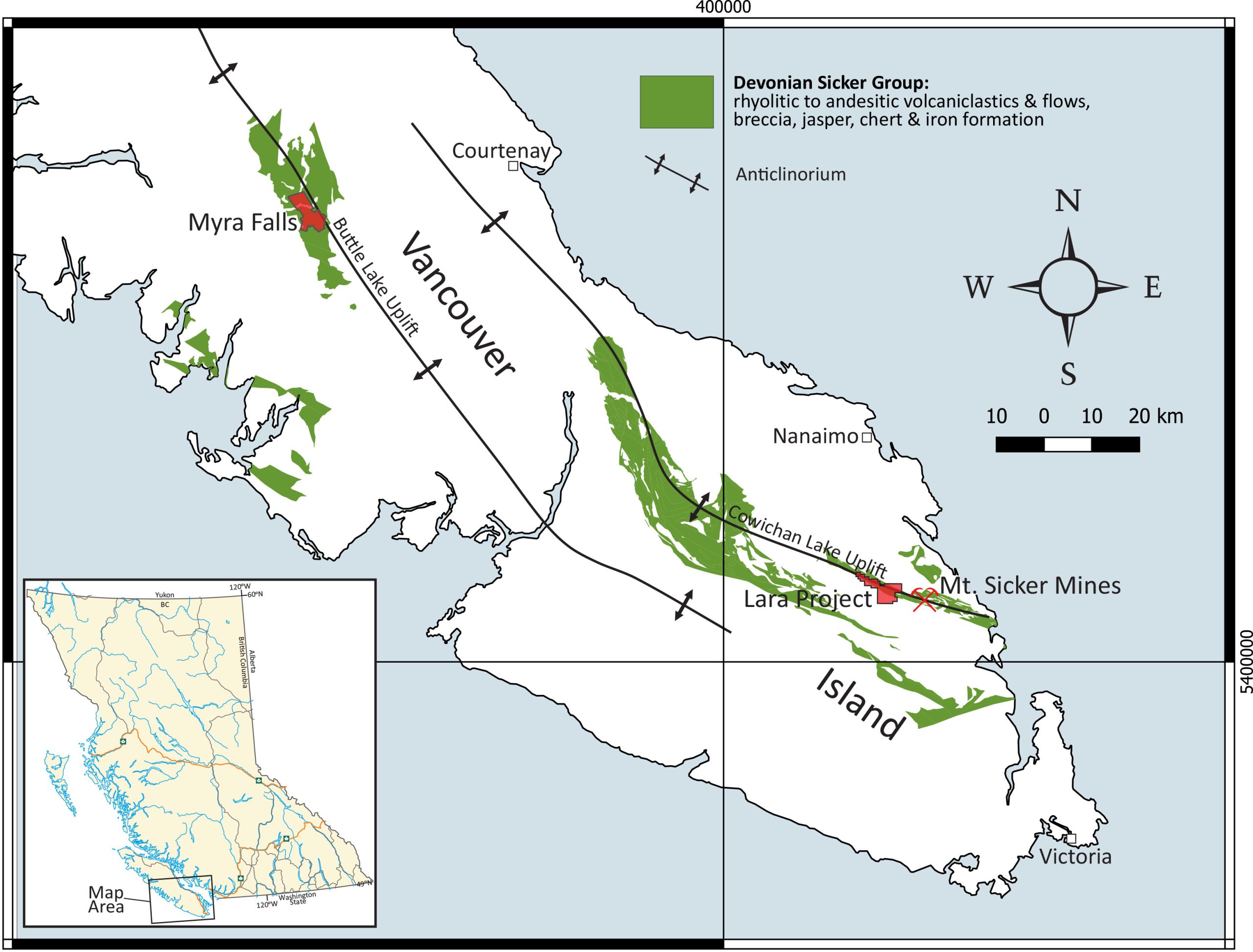
The Lara Project contains a polymetallic volcanogenic massive sulphide (VMS) deposit hosting gold, silver, copper, zinc, and lead. The Property is underlain by the McLaughlin Ridge Formation (Cowichan Lake uplift) which is correlative with the Myra Formation (Buttle Lake uplift) sequence of bimodal volcaniclastic rocks that hosts the Zinc (Zn)-Lead (Pb)-Copper (Cu)-Silver (Ag)-Gold (Au) VMS deposit of Myra Falls (~145 km to the north). The past producing Zn-Cu-Pb-Ag-Au mine and mineralized zones at Mt. Sicker, ~9 km southeast of the Property, are also hosted by the McLaughlin Ridge Formation (Belik, 1981; MINFILE, 1990a).
The Lara Project was the subject of previous exploration activity in the 1980’s consisting of 323 historical drill holes totalling more than 58,263 meters, as well as 679 meters of pre-production underground access and drifting. The most recent exploration work on the Property was a carried out in 1998 by Nucanolan Resources Ltd. who completed a diamond drilling program of 12 drill holes (2,559 meters) with their best reported intersection of 3.16 m@ 2.48% Cu, 1.19% Pb, 12.3% Zn, 49.80 g/t Ag and 2.30 g/t Au.
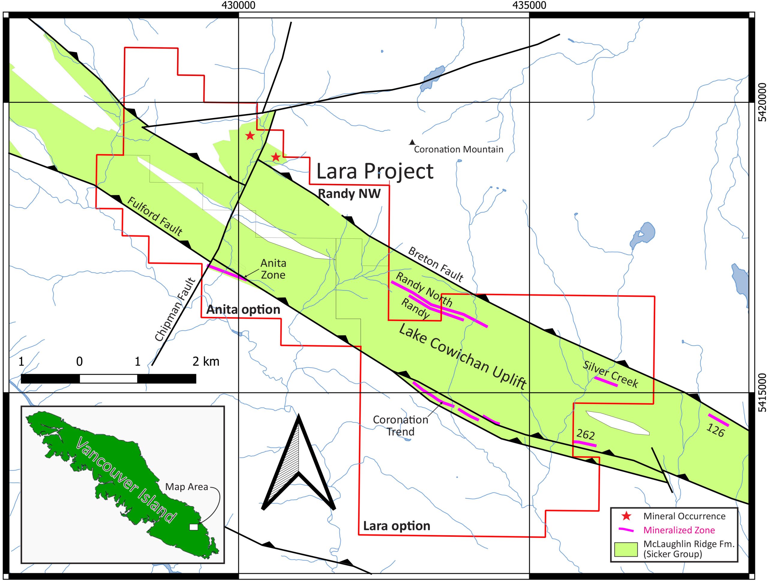
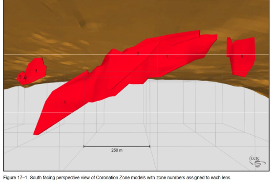
A Mineral Resource Estimate was completed on the mineralized zones within the Coronation Trend in 2008. In most instances, the significant intersections were reconciled from section to section without the inclusion of low-value intervals. The Coronation Trend was modeled as six discrete zones with a total strike length of approximately 1,180 meters along a 118° trend. The average dip of the zones is approximately 65° to the north-northeast. The true width of the zone models ranges from 2 to 15 meters and averages approximately 5 meters.
The presence of additional polymetallic zones in a predominantly felsic volcanic package and the presence of numerous untested geochemical and geophysical anomalies are encouraging for continued exploration on the Property. These features are complimented by existing infrastructure including nearby power and population centers.
The issuer is not treating the historical estimate as current mineral resources or mineral reserves
Project Overview
Critical Element, Polymetallic Resource
Zinc, Copper, Lead, Gold and Silver
Ownership
Option to earn 100% (vendors retain 2% NSR)
Stage
Developed Prospect
Size
1,848.1 Hectares
Number of Drill Holes to Date
323 drill holes, totalling 58,262 meters
Underground development:
679 meters of pre-production underground access and drifting (1989)
Note: 1% is the equivalent of 22lbs, resource estimates at 1% zinc cutoff (43-101 2024 report)
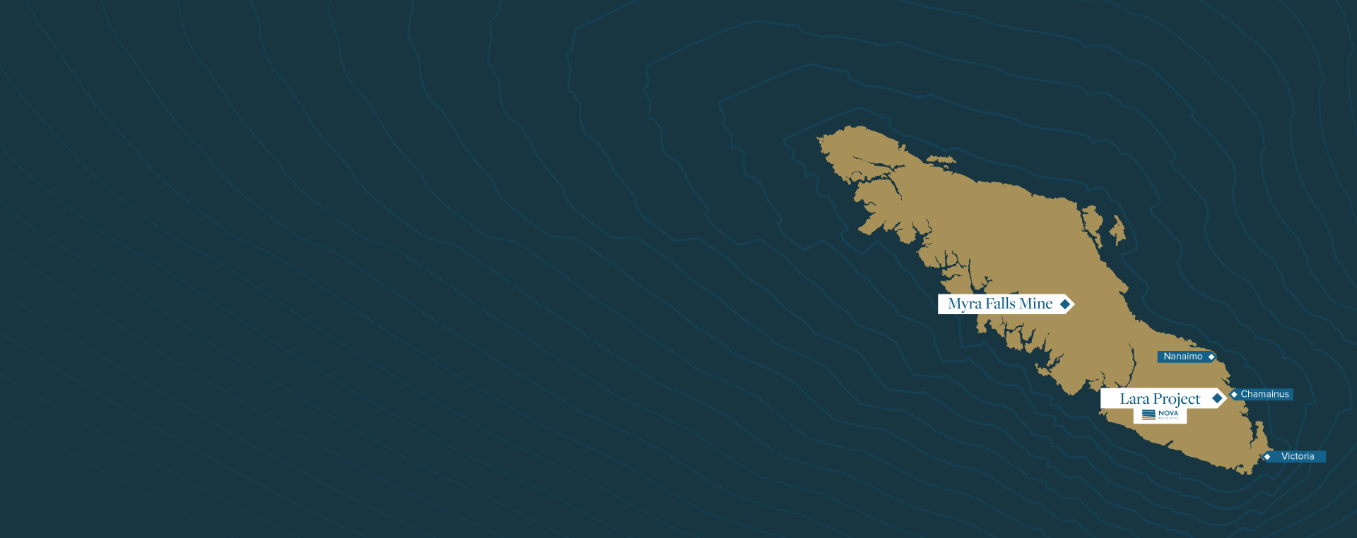
Location
The Lara Property, located in the southern part of Vancouver Island, lies approximately 64 km northwest of Victoria, 15 km west of the port of Chemainus and 12 km west of the Village of Chemainus, British Columbia, Canada.
What is a VMS Deposit?
Franklin et. al. (2005) defined volcanogenic massive sulphide deposits as stratabound accumulations of sulphide minerals that precipitated at or near the sea floor. All VMS deposits occur in terrains dominated by volcanic rocks, although individual deposits may be hosted by volcanic or sedimentary rocks that form part of the overall volcanic complex (Franklin, 1996). VMS deposits primarily occur in subaqueous, rift related environments (i.e. oceanic, fore-arc, back-arc, continental margins, or continental) and hosted by bi-modal mafic-felsic successions, where the felsic volcanic rocks have specific geochemical characteristics.Lara has previously been classified as a VMS deposit because of the apparent stratabound nature of the mineralized zone. The deposit has been further classified as belonging to the Bimodal Felsic sub-type of VMS deposits, as defined by Galley et al. (2007). This sub-type typically contains a barite cap and generally contains more precious metals than most VMS deposits.

Geology and Mineralization
Nova Pacific Metals’ Lara Property is situated in the belt of rocks that hosts the nearby Mt. Sicker VMS deposits, in a geological setting similar to the Myra Falls Mine (pre-mining resource estimate of over 40 Mt grading 1.8% Cu, 6.1% Zn, 0.5% Pb, 49.0 g/t Ag & 2.1 g/t Au) to the northwest. Note to reader: Proximity to former producing mines may not be indicative of the potential of the Lara Project
The Property is underlain by a package of bimodal volcaniclastic rocks assigned to the McLaughlin Ridge Formation (MRF) of the Devonian Sicker Group, which hosts all of the massive sulphide mineralization. The MRF occurs at the core of an open anticline and is flanked by sedimentary rocks of the overlying Carboniferous-Permian Fourth Lake Formation of the Buttle Lake Group. These rocks have all been intruded by gabbros coeval with the Upper Triassic Karmutsen Formation, which together are unconformably overlain by clastic sediments of the Upper Cretaceous Nanaimo Group. Late, brittle faults, including at least one splay of the Fulford Fault, cut all these rocks.
Additional Highlights
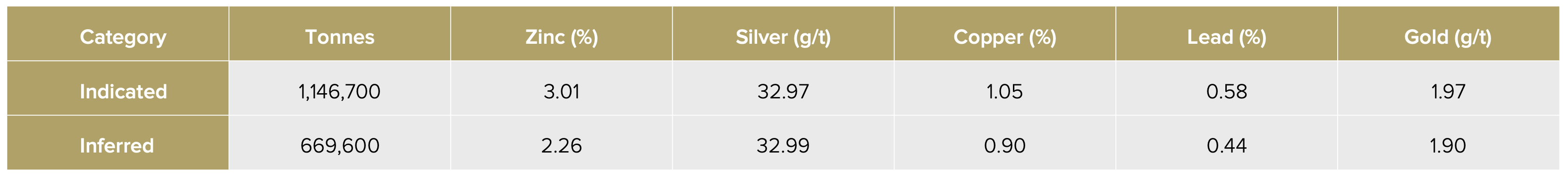
- A non current indicated resource of 1,146,700 tonnes at 3.01% Zn, 32.97 g/t Ag, 1.05% Cu, 0.58% Pb and 1.97g/t Au and inferred of 669,600 tonnes at 2.26% Zn, 32.99 g/t Ag, 0.90% Cu, 0.44% Pb and 1.90 g/t Au at a 1% Zn cut-off. NATIONAL INSTRUMENT 43-101 INDEPENDENT TECHNICAL REPORT10.07-2024. *
- One massive sulphide lens exposed by trench 86-43 (ARIS 29840) in the Coronation Zone graded 24.58 g/t Au, 513.6 g/t Ag, 3.04% Cu, 43.01% Zn and 8.30% Pb over 3.51 m. Repeated sampling of 86-43 trench returned very similar grades in 2006 and by portable XRF in 2024.
- The Coronation Trend consists of several stratiform massive sulphide lenses within an envelope of banded or laminated sulfides. The Trend is made up of three zones: the original discovery of the Coronation Zone, the Coronation Extension Zone (east and stratigraphically above the Coronation Zone) and the Hanging Wall Zone which consists of stringer mineralization that is also stratigraphically above the Coronation Zone (Roscoe and Postle, 1988).
- The Coronation sulphide mineralization exhibits variation in thickness from 3 to 16 meters, averaging about 6 meters (Crick, 2003; MINFILE, 1990a).


Overall Interpretation
The deposit type on the Lara Property is classified as Kuroko-type massive sulphides comprising volcanic-hosted, stratiform accumulations of sphalerite, pyrite, chalcopyrite, galena and tetrahedrite.It is the most significant VMS deposit outside of the Mt. Sicker deposits in the area and occurs at shallow depths of <150 m below surface. Previous metallurgical testing and pre-feasibility studies (Roberts, 2007; Broughton, 1987) although not current, demonstrate the possibility that the deposit could be economic and deserves further investigation. Furthermore, there is abundant exploration potential to depth and along strike along the Coronation Trend to warrant additional exploration as VMS deposits such of these tend to occur as clusters including the most immediate analogues (Mt. Sicker and Buttle Lake Myra Falls deposits). Proximity to former producing mines may not be indicative of the potential of the Lara Project.
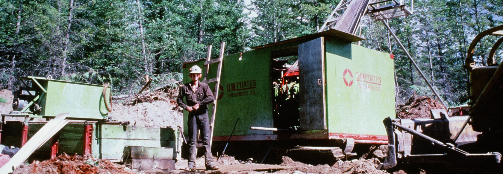
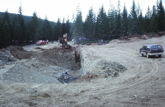
Exploration History
Since the 1980’s, a substantial amount of exploration work has been completed at the Lara project with approximately 323 diamond drill holes totaling over 58,000 m, as well as 679 m of pre-production underground development (decline, drifting, crosscuts and raises) on the Coronation Zone. The main resource, also known as the Coronation Trend, was modeled using Datamine Studio as six discrete zones and consists of continuous pods of zinc and gold rich mineralization. The historical resource estimate is based on the Coronation Trend, which includes the Coronation Zone, the Coronation Extension and the Hanging Wall deposits. In 2008, Caracle Creek International Consulting completed a historic resource for Treasury Metals Inc. described in an Independent Technical Report and Mineral Resource Estimation, Lara Polymetallic Property, April 2008 (Iain Kelso, H.B.Sc., P.Geo., and Stephen Wetherup, B.Sc., P.Geo., co-authors). This report was updated in 2024.

1981
Work Begins
1983
Geological mapping, geophysical and geochemical surveys and backhoe trenching completed
1984
12 diamond drill holes completed (1,346 metres; backhoe trenching). Discovery of Coronation Zone(discovery hole: 7.95 m of 0.68% Cu, 0.45% Pb, 3.01% Zn, 67.54 g/t Ag, 3.46 g/t Au)
1985
61 diamond drill holes completed (7,437 m)
1985
Discovery of Coronation Extension (3.03 m of 1.16% Cu, 2.53% Pb, 9.22% Zn, 8.6 g/t Ag, 0.213 oz/Au)
1986
Discovery of Randy North Zone - Coronation Trend – Trench 86-43 (width of 3.51m of 3.04% Cu, 43.01% Zn, 8.3% Pb, 513.6 g/t Ag, 24.58 g/t Au)
1986
75 Diamond drill holes completed (11,339m). Mineralogical testing by CANMET
1987
Delineate Coronation Trend. Randy North Zone 83 Diamond drill holes (15,038 m)
1987
Black Monday Stock Market Crash
1988
Diamond drilling (surface included). Metallurgical testing from Coronation. Underground work: 770m of ramping and drifting at Coronation Zone
1989
Delineate extent of Coronation Trend, geological work, lithological sampling, line-cutting, geophysical surveys (EM and IP). 43 Diamond drill holes (10,328 m). Reclamation and closure plan prepared
1990
Exploration focussed on the 262 Felsic volcanic rocks defining the structural hanging wall to the Coronation Trend. 49 Diamond drill holes (11,167m)
1998
Operations suspended due to depressed metal prices.
1998
Nucanolan option the property. 12 drill holes at Coronation Trend (2,559 m)
2000
Dot Com Bubble
2007
Airborne TDEM geophysical survey, drill core re-sampling and resource estimate on the Lara property. According to Carracle Creek International Consulting Inc (CCIC) who conducted the work on behalf of Laramide states: "It is of the opinion of CI that the results of the core duplicate assaying positively attest to the veracity of the historic sample data base."
2007
Resource Estimate
2008
Financial Crisis
2014
Mapping, whole rock geochemical sampling and a Preliminary Environmental Baseline Study.
June 2014 to Feb 2015
Global commodity prices fell 38%
2018
Lidar survey on the Lara property
2020
COVID-19 Pandemic
2024
Nova acquired the Lara claims.
Historical, Non-current, Mineral Resource Summary
Independent Technical Report (Kelso & Wetherup, 2008)
1% Zn Block Cut-off*
2008 Moving average values (USD) utilized to calculate metal equivalents as follows:
Copper: $1.59/lb , Lead:$0.45/lb, Zinc: $0.68/lb , Silver: $7.00/oz, Gold: $430.00/oz
2% Zn Block Cut-off*
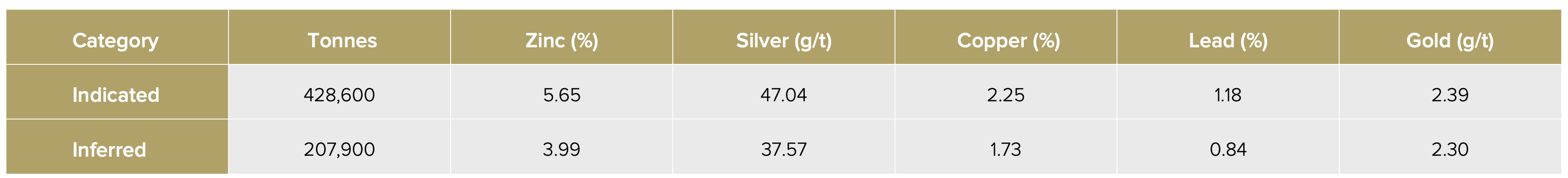
*Nova Pacific Metals has not done sufficient exploration to classify the historical estimate as a current resource, and the Company is not treating the historical estimate as a current resource.
The historical estimate was prepared using wireframe models for zinc thresholds, with grade interpolation completed using the inverse power of distance method. The reliability of the historical estimate is considered reasonable, but a Qualified Person has not completed sufficient work to classify the historical estimate as a current mineral resource and the Company is not treating the historical estimate as a current mineral resource. To upgrade the historical resource to a current resource a constrained mineral estimation should be constructed by a Qualified Person. Nova intends to confirm previous historical results with a 40 hole drill program currently in the planning stage.
Project Details
The Lara project has seen extensive exploration activity starting in 1981. With its easy year-round access, mild weather and close proximity to infrastructure it’s poised to see a resurgence of exploration activity starting in early 2025. Nova’s Lara claims currently have some 323 historical diamond drill holes completed for a total of 58,000m, including 23 underground drill holes and 670m of underground workings. Historically the focus has been on the Coronation Trend but there exist 3 more zones that warrant further exploration (Randy North zone, Silver Creek zone, 262 zone).
Wireframe models generated represent a threshold above which a continuous zone of >1.0% Zinc-Equivalent (“ZnEq”) could be consistently followed and modelled. A 4 year moving average price was calculated in November 2006 and assigned as the value for each commodity. Grade Interpolation Method: inverse power of distance. Additional infill drilling has been recommended in order to generate a NI 43-101-compliant resource estimate
*The mineral resources quoted above are historical in nature and the reader is cautioned when analyzing this data as the Company has not yet conducted exploration necessary to re-confirm these results.
*Historical estimate means an estimate of the quantity, grade, or mineral content of a deposit that an issuer has not verified as a current mineral resource or mineral reserve.
